Share to:


Analamazaotra National Park

Analamazaotra National Park
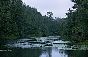
Analamazaotra National Park, November 1998
Map showing the location of Analamazaotra National Park
Location of Analamazaotra National Park
LocationAlaotra-Mangoro, Madagascar
Coordinates18°56′10″S 48°25′42″E / 18.93611°S 48.42833°E / -18.93611; 48.42833
Area26.53 km2 (10.24 sq mi)
Established1970 (special reserve), 21 April 2015 (national park)
Governing bodyMadagascar National Parks Association

Analamazaotra National Park is a national park of Madagascar. The park is in the eastern portion of Madagascar's Central Highlands. The neighbouring Analamazaotra Forest Station is a local reforestation effort. It adjoins Andasibe-Mantadia National Park to the north.

The reserve is situated in the region Alaotra-Mangoro, close to Moramanga and Andasibe.[2]

Analamazaotra National Park is located 27 kilometres (17 mi) from Moramanga and is bordered on the south by National road 2, a secondary road to Andasibe and a railway line between Antananarivo and Toamasina.

Conservation

Analamazaotra Special Reserve, also known as Périnet-Analamazaotra, was established in 1970. On 21 April 2015, the special reserve was combined with the adjacent Analamazaotra Forest Station to create Analamazaotra National Park via Decree No. 2015-732.[3]

References

  1. ^ UNEP-WCMC (2022). Protected Area Profile for Analamazaotra Archived 11 December 2022 at the Wayback Machine from the World Database on Protected Areas. Accessed 11 December 2022.
  2. ^ "Analamazaotra National Park". Archived from the original on 24 June 2021. Retrieved 22 June 2021.
  3. ^ AnalamazaotraSite #42 Archived 7 November 2022 at the Wayback Machine. Madagascar Protected Areas. Accessed 11 December 2022.


Prefix: a b c d e f g h i j k l m n o p q r s t u v w x y z 0 1 2 3 4 5 6 7 8 9

Portal di Ensiklopedia Dunia

Kembali kehalaman sebelumnya