Share to:


Berjou

Berjou
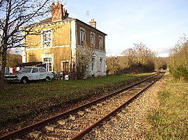
The railway station in Berjou
Location of Berjou
Map
Berjou is located in France
Berjou
Berjou
Berjou is located in Normandy
Berjou
Berjou
Coordinates: 48°51′01″N 0°28′51″W / 48.8503°N 0.4808°W / 48.8503; -0.4808
CountryFrance
RegionNormandy
DepartmentOrne
ArrondissementArgentan
CantonAthis-Val de Rouvre
IntercommunalityCA Flers Agglo
Government
 • Mayor (2020–2026) Didier Vieceli[1]
Area
1
8.82 km2 (3.41 sq mi)
Population
 (2022)[2]
427
 • Density48/km2 (130/sq mi)
Time zoneUTC+01:00 (CET)
 • Summer (DST)UTC+02:00 (CEST)
INSEE/Postal code
61044 /61430
Elevation58–257 m (190–843 ft)
(avg. 200 m or 660 ft)
1 French Land Register data, which excludes lakes, ponds, glaciers > 1 km2 (0.386 sq mi or 247 acres) and river estuaries.

Berjou (French pronunciation: [bɛʁʒu] ) is a commune in the Orne department in northwestern France.

Geography

The commune is part of the area known as Suisse Normande.[3]

The commune is made up of the following collection of villages and hamlets, Cambercourt,Les Oiseaux, Les Cours,Le Hamel, La Trollière, Le Fang, Vervent and Berjou.[4]

The Commune with another 20 communes shares part of a 2,115 hectare, Natura 2000 conservation area, called the Vallée de l'Orne et ses affluents.[5]

The commune has the river Noireau running through it.

Population

Historical population
YearPop.±% p.a.
1968 473—    
1975 522+1.42%
1982 535+0.35%
1990 525−0.24%
1999 508−0.37%
2009 475−0.67%
2014 492+0.71%
2020 446−1.62%
Source: INSEE[6]

Places of interest

  • Museum of the liberation of Berjou was opened in 2011 and retraces the fighting of August 15, 16 and 17, 1944 around the River Noireau as part of the battle of the Falaise pocket.[7][8]
Notre-Dame church in Berjou

See also

References

  1. ^ "Répertoire national des élus: les maires". data.gouv.fr, Plateforme ouverte des données publiques françaises (in French). 2 December 2020.
  2. ^ "Populations de référence 2022" (in French). The National Institute of Statistics and Economic Studies. 19 December 2024.
  3. ^ "Map of Suisse Normande" (PDF).
  4. ^ a b "Google Maps". Google Maps.
  5. ^ "INPN - FSD Natura 2000 - FR2500091 - Vallée de l'Orne et ses affluents - Description".
  6. ^ Population en historique depuis 1968, INSEE
  7. ^ "Histoire. Le musée de la Libération de Berjou va rouvrir, samdi 6 juin 2020". actu.fr. 7 May 2020.
  8. ^ "D-Day landings: Remembering the Battle of Berjou". 9 June 2014 – via www.bbc.co.uk.


Kembali kehalaman sebelumnya