Share to:


Clais

Clais
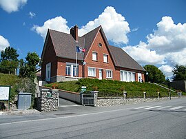
The town hall and school in Clais
Location of Clais
Map
Clais is located in France
Clais
Clais
Clais is located in Normandy
Clais
Clais
Coordinates: 49°48′31″N 1°27′01″E / 49.8086°N 1.4503°E / 49.8086; 1.4503
CountryFrance
RegionNormandy
DepartmentSeine-Maritime
ArrondissementDieppe
CantonNeufchâtel-en-Bray
IntercommunalityCC Londinières
Government
 • Mayor (2020–2026) Vincent Leborgne[1]
Area
1
12.45 km2 (4.81 sq mi)
Population
 (2022)[2]
263
 • Density21/km2 (55/sq mi)
Time zoneUTC+01:00 (CET)
 • Summer (DST)UTC+02:00 (CEST)
INSEE/Postal code
76175 /76660
Elevation86–224 m (282–735 ft)
(avg. 98 m or 322 ft)
1 French Land Register data, which excludes lakes, ponds, glaciers > 1 km2 (0.386 sq mi or 247 acres) and river estuaries.

Clais (French pronunciation: [klɛ]) is a commune in the Seine-Maritime department in the Normandy region in northern France.

Geography

A farming village situated by the banks of the river Eaulne in the Pays de Bray, some 24 miles (39 km) southeast of Dieppe, at the junction of the D1314 and the D14 roads.

Population

Historical population
YearPop.±% p.a.
1968 289—    
1975 259−1.55%
1982 244−0.85%
1990 209−1.92%
1999 202−0.38%
2007 207+0.31%
2012 237+2.74%
2017 259+1.79%
Source: INSEE[3]

Places of interest

  • The church of St.Martin, dating from the eleventh century.

See also

References

  1. ^ "Répertoire national des élus: les maires" (in French). data.gouv.fr, Plateforme ouverte des données publiques françaises. 13 September 2022.
  2. ^ "Populations de référence 2022" (in French). The National Institute of Statistics and Economic Studies. 19 December 2024.
  3. ^ Population en historique depuis 1968, INSEE


Kembali kehalaman sebelumnya