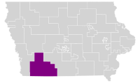
American legislative district
Iowa's 9th
State Senate district |
|---|
|
 |
| Senator | |
|---|
The 9th District of the Iowa Senate is located in southwestern Iowa, and is currently composed of Adams, Cass, Montgomery, Page, Ringgold, Taylor, and part of Union counties. [1]
Current elected officials
Tom Shipley (politician) is the senator currently representing the 9th District.
The area of the 9th District contains two Iowa House of Representatives districts:[2]
The district is also located in Iowa's 3rd congressional district, which is represented by U.S. Representative Zach Nunn.[3]
List of representatives
[4]
| Representative
|
Party
|
Dates
|
Residence
|
Notes
|
| Francis Springer
|
|
Whig
|
1846-1849
|
Columbus Junction, Iowa
|
|
| Norman Everson
|
|
Whig
|
1850-1851
|
Washington, Iowa
|
|
| Amos Harris
|
|
Democrat
|
1852-1853
|
Centerville, Iowa
|
|
| Nathan Udell
|
|
Democrat
|
1854-1855
|
Appanoose County
|
|
| Daniel Anderson
|
|
Republican
|
1856-1859
|
Albia, Iowa
|
|
| Alvin Saunders
|
|
Republican
|
1860-1861
|
Mount Pleasant, Iowa
|
Saunders was appointed to be the Governor of the Nebraska Territory in 1861 by President Abraham Lincoln
|
| Leroy Palmer
|
|
Republican
|
1861
|
Mount Pleasant, Iowa
|
|
| Theron Woolson
|
|
Republican
|
1862-1863
|
Henry County
|
|
| John Foote
|
|
Republican
|
1864-1865
|
Burlington, Iowa
|
|
| Fitz Warren
|
|
Republican
|
1866-1867
|
Des Moines County
|
|
| Jefferson Casady
|
|
Democrat
|
1868-1871
|
Council Bluffs, Iowa
|
|
| John Stone
|
|
Republican
|
1872-1875
|
Glenwood, Iowa
|
|
| George Franklin Wright
|
|
Republican
|
1876-1877
|
Council Bluffs, Iowa
|
Not to be confused with George G. Wright, though George F. Wright did work for and with George G. Wright in Keosauqua, Iowa.[5]
|
| John Patterson
|
|
Republican
|
1878-1881
|
Des Moines County
|
|
| Benton Jay Hall
|
|
Democrat
|
1882-1884
|
Des Moines County
|
Hall was elected to the United States House of Representatives in 1884.
|
| William Dodge
|
|
Democrat
|
1886-1893
|
Des Moines County
|
|
| Thomas Harper
|
|
Democrat
|
1894-1897
|
Burlington, Iowa
|
|
| William McArthur
|
|
Republican
|
1898-1901
|
Burlington, Iowa
|
|
| Frederick Smith
|
|
Democrat
|
1902-1910
|
Des Moines County
|
|
| LaMonte Cowles
|
|
Republican
|
1911-1914
|
Burlington, Iowa
|
|
| Frank Thompson
|
|
Republican
|
1915-1922
|
Burlington, Iowa
|
|
| Edward Romkey
|
|
Republican
|
1923-1926
|
Burlington, Iowa
|
|
| Clyde Topping
|
|
Republican
|
1927-1934
|
Burlington, Iowa
|
|
| James M. Bell
|
|
Democrat
|
1935-1938
|
Burlington, Iowa
|
|
| Frederick Cromwell
|
|
Republican
|
1939-1946
|
Burlington, Iowa
|
|
| William Skourup
|
|
Republican
|
1947-1950
|
Burlington, Iowa
|
|
| Thomas Dailey
|
|
Democrat
|
1951-1958
|
Burlington, Iowa
|
|
| Carl Hoschek
|
|
Democrat
|
1959-1962
|
Burlington, Iowa
|
|
| Jacob Mincks
|
|
Democrat
|
1963-1966
|
Wapello County
|
|
| Gene Glenn
|
|
Democrat
|
1967-1970
|
Ottumwa, Iowa
|
|
| Leigh Curran
|
|
Republican
|
1971-1972
|
Mason City, Iowa
|
|
| Dale Tieden
|
|
Republican
|
1973-1982
|
Elkader, Iowa
|
|
| Ray Taylor
|
|
Republican
|
1983-1994
|
Steamboat Rock, Iowa
|
|
| Stewart Iverson
|
|
Republican
|
1995-2002
|
Wright County
|
|
| Robert Brunkhorst
|
|
Republican
|
2003-2006
|
Waverly, Iowa
|
|
| William Heckroth
|
|
Democrat
|
2007-2010
|
Waverly, Iowa
|
|
| Bill Dix
|
|
Republican
|
2011-2012
|
Shell Rock, Iowa
|
|
| Nancy Boettger
|
|
Republican
|
2013-2014
|
Harlan, Iowa
|
|
| Jason Schultz
|
|
Republican
|
2015-2022
|
Schleswig, Iowa
|
|
| Tom Shipley
|
|
Republican
|
2023-Present
|
Adams County
|
|
Historical District Boundaries
Source:[6]
See also
References


