|
Llŷn Coastal Path
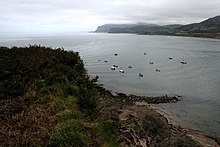
North Wales Path 53°08′42″N 4°16′08″W / 53.145°N 4.269°W      The Llŷn Coastal Path (Welsh: Llwybr Arfordir Llŷn) is a waymarked 146-kilometre (91 mi) long-distance footpath running along the coast of the Llŷn Peninsula from Caernarfon to Porthmadog in Gwynedd, north-west Wales. A large part of the Llŷn Peninsula is designated an Area of Outstanding Natural Beauty.[1] Devised and implemented by Gwynedd County Council and the Countryside Council for Wales, the path opened in 2006, though it has since been changed and improved. This work is continuing as part of the path's integration into the Wales Coast Path, an 870-mile (1,400 km) long-distance walking route around the whole coast of Wales from Chepstow to Queensferry.[2] DescriptionThe route passes through hidden coves and beaches, along cliff-top paths, through small harbours and towns such as Caernarfon and Porthmadog, detours slightly inland where it rises to as much as 980 feet (300 m) and covers the coast of both north and south Llŷn. Snowdonia, Wales’ biggest National Park, lies to the east and the Irish Sea to the west. The weather in these parts can be unpredictable. The Coastal Path is partly based on an ancient pilgrimage route to Bardsey Island, now a National Nature Reserve.[3] Wildlife is abundant in this area, and bottle-nosed dolphins and Atlantic grey seals can often be seen in the coastal waters. In the dunes there are stonechats, goldfinches, and sand martins. Migratory birds pass this way too, so autumn brings the arrival of redwings, chaffinches, starlings and skylarks.[3] The rare chough breeds in small numbers.[4] The routeThe route can be split into seven main sections,[5] though the official guidebook divides it into nine.[6]
See alsoReferences
External links |
