|
Lurøy Municipality
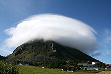
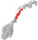
Lurøy is a municipality in Nordland county, Norway. It is part of the Helgeland traditional region. The administrative centre of the municipality is located on the island of Onøya. Other villages in Lurøy include Aldra, Haugland, Konsvikosen, Lovund, Lurøy, Sleneset / Solværøyene, Stokkvågen, and Tonnes. The municipality is located on the coast just south of the Arctic Circle, on the western edge of the Saltfjellet mountain range. The Lurøygården (Lurøy Farm) on the island of Lurøya is a more-than-200-year-old renaissance garden with old plants, a pool, and a nearly 20-metre (66 ft) high Copper Beech. The 265-square-kilometre (102 sq mi) municipality is the 275th largest by area out of the 357 municipalities in Norway. Lurøy is the 288th most populous municipality in Norway with a population of 1,886. The municipality's population density is 7.1 inhabitants per square kilometre (18/sq mi) and its population has decreased by 0.8% over the previous 10-year period.[5][6] General information Lurøy was established as a municipality on 1 January 1838 (see formannskapsdistrikt law). On 1 January 1872, the far western island district (population: 289) was separated from Lurøy to become the new Træna Municipality. This left Lurøy with 1,554 residents. The borders of Lurøy have not changed since that time.[7] NameThe municipality (originally the parish) is named after the island of Lurøya (Old Norse: Lúðrøy) since the first Lurøy Church was built there. The first element is lúðr which means "hollowed log" (here probably referring to the form of the mountain of the island). The last element is øy which means "island".[8] Historically, the name of the municiaplity was spelled Lurø. On 6 January 1908, a royal resolution changed the spelling of the name of the municipality to Lurøy.[9] Coat of armsThe coat of arms was granted on 22 August 1986. The official blazon is "Or, a navigation cairn sable" (Norwegian: I gull en svart sjøvarde). This means the arms have a field (background) that has a tincture of Or which means it is commonly colored yellow, but if it is made out of metal, then gold is used. The charge is black navigational cairn. This was chosen to symbolize the local dependence on fishing and sailing in this island municipality. The arms were designed by Olga Nilsen after a proposal by Dagmar Vilfridadottir Olaisen.[10][11][12] ChurchesThe Church of Norway has two parishes (sokn) within Lurøy Municipality. It is part of the Nord-Helgeland prosti (deanery) in the Diocese of Sør-Hålogaland.
Geography and climateLurøy is located on the western coast of Helgeland. The small strip of mainland Lurøy runs from Tonnes in the north along Norwegian County Road 17 to Stokkvågen along the Sjona fjord in the south. The rest of the municipality is located on 1,375 islands located to the west of the mainland. The major islands include Aldra, Lurøya, Onøya, Stigen, Solvær, and Lovund. There are also two islands in the northern part of Lurøya that are divided between Lurøy and neighboring Rødøy Municipality: Nesøya and Hestmona.[13] The highest point in the municipality is the 1,172.7-metre (3,847 ft) tall mountain Strandtindan, a tripoint on the border of Lurøy Municipality, Rødøy Municipality, and Rana Municipality.[1] The populated islands are reached by car ferry from Stokkvågen on the mainland. The ferry reaches Onøy (which has a bridge to Lurøya), Solvær and Lovund 5 times per day. ClimateThe Norwegian Meteorological Institute has operated weather stations on Solvær islands since 1939. Data shows a marine west coast climate (oceanic climate) with very mild winters for the high latitude. Spring and summer are the driest seasons, while December is the wettest month. The all-time high was recorded in July 2018, and the all-time low is from February 1966. The average date for the last overnight freeze (low below 0 °C (32.0 °F)) in spring is 20 April[14] and average date for first freeze in autumn is 5 November[15] giving a frost-free season of 198 days (1981-2010 average for Solvær).
Farms of LurøyHistorically, the land of Lurøy was divided up into named farms. These farms were used in census and tax records and are useful for genalogical research. Farm mapsNote: Coordinates are approximate. The map has been divided into parts consistent with the enumeration districts (Norwegian: tellingskrets) in the 1920 census of Norway. This map will include one farm name per farm number; other farm names or subdivision numbers may exist. Lurøy 
4km
2.5miles
56: Moflag church
Aldersund church 55
54: Lovund church
Lurøy church 53
52: Lurøy school 51 50 49 48 47 46 45 44 43 42 41 40 39 38 37 36 35 34 33 32 31 30 29 28 27 26 25 24 23 22 21 20 19 18 17 16 15 14 13 12 11 10 9 8 7 6 5 4 3
2
1 Farms: 1 Lovunden2 Grønningen3 Troldøen4 Sengsdraget5 Juløen6 Risvær7 Solvær søndre8 Moflaget9 Slaaterøen10 Ulvøen11 Lunderøen12 Solvær norde13 Reløen14 Kvitvær15 Sandvær16 Maavær17 Sutternes18 Lurøen19 Svinøen20 Onøen indre21 Onøen ytre22 Stoksvik23 Sjonøen24 Sundet25 Klippingvaag26 Silen27 Bogen28 Røitvik29 Selnes30 Haugland31 Aas (Ås)32 Vatnet33 Bratland34 Lien35 Olvikvatnet36 Alderen37 Hjart38 Aspnes39 Ørnes40 Stuvland41 Okstind42 Fingammen43 Kvinen44 Konsvik45 Kokviken46 Aspdalen47 Tonnes48 Kvarøen indre49 Kvarøen ytre50 Hestmoen51 Nesøen søndre52 Lurøy school53 Lurøy church (built 1812)54 Lovund church (built 1960)55 Aldersund church (built 1971)56 Moflag church (built 1921) Farm names and numbersFollowing are the farms in Lurøy municipality, as they are listed in O. Rygh's series "Norske Gaardnavne" ("Norwegian Farm Names"), the Nordland volume of which was published in 1905.
The farm numbers are used in some census records, and numbers that are near each other indicate that those farms are geographically proximate. Handwritten Norwegian sources, particularly those prior to 1800, may use variants on these names. For recorded variants before 1723, see the digital version of O. Rygh. Farm names were often used as part of Norwegian names, in addition to the person's given name and patronymic or inherited surname. Some families retained the farm name, or toponymic, as a surname when they emigrated, so in those cases tracing a surname may tell you specifically where in Norway the family was from. This tradition began to change in the mid to late 19th century, and inherited surnames were codified into law in 1923. If you can't find an entry when you are searching for a word that starts with AE, Ae, O, A or Aa, it may have been transcribed from one of those letters not used in English. Try looking for it under the Norwegian letter; Æ, Ø, and Å appear at the end of the Norwegian alphabet.
GovernmentLurøy Municipality is responsible for primary education (through 10th grade), outpatient health services, senior citizen services, welfare and other social services, zoning, economic development, and municipal roads and utilities. The municipality is governed by a municipal council of directly elected representatives. The mayor is indirectly elected by a vote of the municipal council.[17] The municipality is under the jurisdiction of the Helgeland District Court and the Hålogaland Court of Appeal. Municipal councilThe municipal council (Kommunestyre) of Lurøy is made up of 19 representatives that are elected to four year terms. The tables below show the current and historical composition of the council by political party.
MayorsThe mayor (Norwegian: ordfører) of Lurøy is the political leader of the municipality and the chairperson of the municipal council. Here is a list of people who have held this position:[37]
Media gallery
Notable people
References
External links
|
|||||||||||||||||||||||||||||||||||||||||||||||||||||||||||||||||||||||||||||||||||||||||||||||||||||||||||||||||||||||||||||||||||||||||||||||||||||||||||||||||||||||||||||||||||||||||||||||||||||||||||||||||||||||||||||||||||||||||||||||||||||||||||||||||||||||||||||||||||||||||||||||||||||||||||||||||||||||||||||||||||||||||||||||||||||||||||||||||||||||||||||||||||||||||||||||||||||||||||||||||||||||||||||||||||||||||||||||||||||||||||||||||||||||||||||||||||||||||||||||||||||||||||||||||||||||||||||||||||||||||||||||||||||||||||||||||||||||||||||||||||||||||||||||||||||||||||||||||||||||||||||||||||||||||||||||||||||||||||||||||||||||||||||||||||||||||||||||||||||||||||||||||||||||||||||||||||||||||||||||||||||||||||||||||||||||||||||||||||||||


