|
Mushroom Rock State Park
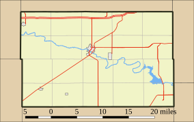
Mushroom Rock State Park is noted for its mushroom rock formations. It is located in the Smoky Hills region of north-central Kansas in Ellsworth County, Kansas, United States. These rocks are the remains of beach sands and sediments of the Cretaceous Period, the interval of geologic time from about 144 to 66 million years ago. Sandstone and sedimentary rock is held together by natural cement. The concretions that make up Mushroom Rocks are cemented calcium carbonate. The largest rock measures 27 feet in diameter.[2] There are two mushrooms and a giant shoe rock, as well as numerous other rock formations in the 5-acre (2.0 ha) park. Mushroom Rock is Kansas's smallest state park;[3] as well as being "one of the 8 wonders of Kansas Geography."[3] Mushroom Rock State Park is managed by Kanopolis State Park,[2] under regulation of Kansas Department of Wildlife, Parks and Tourism. The rock used to serve as meeting places for pioneers and Native Americans.[2] Gallery
See alsoOther rock formations in Kansas: References
External links
|
||||||||||||||||||||||


![Rock formation at Mushroom Rock State Park, Kansas (1916)[4]](http://upload.wikimedia.org/wikipedia/commons/thumb/5/5d/Mushroom_Rock_Kansas_1916.jpg/78px-Mushroom_Rock_Kansas_1916.jpg)
