Share to:


Palms station

Palms
E Line
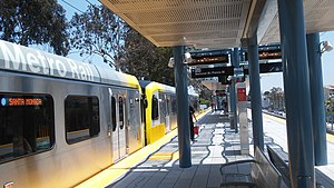
Palms station platform
General information
Location10001 National Boulevard
Los Angeles, California
Coordinates34°01′45″N 118°24′13″W / 34.0291°N 118.4036°W / 34.0291; -118.4036
Owned byLos Angeles County Metropolitan Transportation Authority
Platforms1 island platform
Tracks2
ConnectionsBig Blue Bus
Construction
Structure typeElevated
Bicycle facilitiesMetro Bike Share station,[1] racks and lockers[2]
AccessibleYes
History
OpenedOctober 17, 1875 (1875-10-17)
RebuiltMay 20, 2016 (2016-05-20)[3]
Previous namesThe Palms; Bay View
Passengers
FY 2024957 (avg. wkdy boardings)[4]
Services
Preceding station Metro Rail Following station
Westwood/Rancho Park E Line Culver City
Former services
Preceding station Pacific Electric Following station
Talamantes Air Line Culver Junction
Location
Map

Palms station is an elevated light rail station on the E Line of the Los Angeles Metro Rail system. The station is located over the intersection of National Boulevard and Palms Boulevard in the Palms neighborhood of Los Angeles, after which the station is named.

History

The Palms original depot building from 1875 now at Heritage Square Museum.
Station sign from The Palms train depot now in Heritage Square Museum

Bay View was a stop on the Los Angeles and Independence Railroad. It was renamed The Palms in 1886.[5]

The Eastlake style Palms-Southern Pacific Railroad Depot building was situated approximately 600 yards (550 m) west of the present station, on the south side of the tracks, and remained in active rail service until the closure of the Santa Monica Air Line in 1953.

Used in many motion pictures, the building eventually fell into disrepair and abandonment but was declared a Los Angeles Historic-Cultural Monument in 1963. A grassroots organization, S.O.S. (Save Our Station), moved it in February 1976 to the Heritage Square Museum grounds in the Montecito Heights community of the Arroyo Seco. It now serves as the museum's gift shop and visitor center.[6]

Station name

Originally slated to be renamed "National/Palms" on re-opening, it remains "Palms" as a result of a request by the Palms Neighborhood Council. The council's resolution stated that:

the Pacific Line Palms station was an important landmark on the west side of the city, and the community that grew around it is one of the oldest on the west side of Los Angeles. Our stakeholders feel the naming of the station is not only an important branding opportunity for Palms, but an opportunity for Los Angeles to reinstate a link to the history in one of its oldest and most diverse communities.[7]

On April 25, 2013, the Metro board of directors voted in favor of "Palms" as the official name of the station.[8]

Service

View of Palms station, Los Angeles Metro

Station layout

The station location is adjacent to I-10, just west of the three-way intersection of National, Palms and Exposition boulevards and perched on an embankment above National Boulevard. Access is provided by stairs and elevators at the east end of the station.

Construction incorporated an existing steel bridge from the Air Line era and added a new concrete bridge, both immediately east of the station over the National/Palms intersection, as well as re-using an existing rail tunnel west of the station.[9][verification needed]

Hours and frequency

E Line trains run every day between approximately 4:30 a.m. and 12:30 am. Trains operate every ten minutes during peak hours Monday through Friday, every twelve minutes during the daytime on weekdays and all day on the weekends after approximately 8 a.m. (with 15 to 20-minute headways early Saturday and Sunday mornings). Night service is every 20 minutes.[10]

Connections

As of December 15, 2024, the following connections are available:[11][12]

Points of interest

Attractions within walking distance of Palms station:

References

  1. ^ "Station Map". Metro Bike Share. Archived from the original on January 2, 2022. Retrieved November 13, 2021.
  2. ^ "Secure Bike Parking on Metro" (PDF). Los Angeles County Metropolitan Transportation Authority. Archived from the original (PDF) on September 6, 2021. Retrieved November 5, 2021.
  3. ^ Nelson, Laura J. (May 20, 2016). "Expo Line Service Can Be Less Than Expeditious". Los Angeles Times. pp. A1, A10. Retrieved November 6, 2024 – via Newspapers.com. Open access icon
  4. ^ "FY2024 Ridership by Station". misken67 via Los Angeles Metro Public Records. August 2024.
  5. ^ " "The local of this paper the other day had a look at the 'Palms,' an incipient town on the line of the S. P. road, some five miles from Santa Monica. It is no longer a misnomer as the proprietors have planted two large palms near the depot and some 160 plants on the various driveways." — [1] Archived 2023-03-23 at the Wayback Machine Newspaper account quoted in Ingersoll's Century History, Santa Monica Bay Cities, page 353"
  6. ^ George Garrigues, Los Angeles's The Palms Neighborhood, Charleston:Arcadia Press (2009), page 26 Archived February 8, 2015, at the Wayback Machine ISBN 978-0-7385-6993-2
  7. ^ "Palms station letter" (PDF). Archived (PDF) from the original on July 27, 2011. Retrieved February 23, 2011.
  8. ^ "Steve Hymon, "Board approves station names for Expo Line Phase 2," The Source, April 25, 2013". April 25, 2013. Archived from the original on April 30, 2013. Retrieved April 27, 2013.
  9. ^ Project alternatives Archived July 25, 2011, at the Wayback Machine
  10. ^ "Metro E Line schedule". Los Angeles County Metropolitan Transportation Authority. September 12, 2021. Archived from the original on November 20, 2021. Retrieved November 13, 2021.
  11. ^ "E Line Timetable – Connections section" (PDF). Los Angeles County Metropolitan Transportation Authority. December 15, 2024. p. 1. Retrieved January 13, 2025.
  12. ^ "Little Blue Book" (PDF). Big Blue Bus (Santa Monica). December 15, 2024. Retrieved January 13, 2025.
Prefix: a b c d e f g h i j k l m n o p q r s t u v w x y z 0 1 2 3 4 5 6 7 8 9

Portal di Ensiklopedia Dunia

Kembali kehalaman sebelumnya