Share to:


Tehrathum District

Tehrathum District
तेह्रथुम
Landscape of Tehrathum
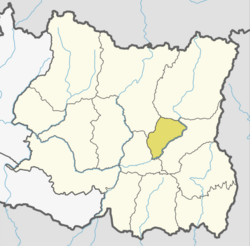
District location of Tehrathum in Koshi Province
Country Nepal
ProvinceKoshi Province
Admin HQ.Myanglung
Government
 • TypeCoordination committee
 • BodyDCC, Tehrathum
Area
 • Total
679 km2 (262 sq mi)
Population
 • Total
88,731
 • Density130/km2 (340/sq mi)
Time zoneUTC+05:45 (NPT)
Telephone Code0092
Websiteddctehrathum.gov.np

Tehrathum District (Nepali: तेह्रथुम जिल्ला pronounced [teɾʌtʰum] ), is one of 14 districts of Koshi Province of Nepal.

Demographics

Historical population
YearPop.±% p.a.
1981 92,454—    
1991 102,870+1.07%
2001 113,111+0.95%
2011 101,577−1.07%
2022 88,731−1.22%
Sources:[1]

In 2021, Terhathum district had a population of 88,731. Tehrathum had a literacy rate of 81.9% and a sex ratio of 1036 females per 1000 males. 34,079 (38.41%) lived in urban municipalities.[2]

Ethnicity/caste of Tehrathum district (2021)[3]

  Limbu (36.40%)
  Chhetri (19.41%)
  Bahun (11.11%)
  Tamang (6.91%)
  Kami (4.32%)
  Damai (3.44%)
  Gurung (3.26%)
  Newar (2.84%)
  Magar (2.78%)
  Rai (1.70%)
  Sherpa (1.58%)
  Sarki (1.50%)
  Bhujel (1.36%)
  Other Hill Janjati (2.19%)
  Others (1.10%)

Ethnicity/caste: 36.40% were Limbu, 19.41% Chhetri, 11.11% Hill Brahmin, 6.91% Tamang, 4.32% Kami, 3.44% Damai/Dholi, 3.26% Gurung, 2.84% Newar, 2.78% Magar, 1.80% Rai, 1.58% Sherpa, 1.50% Sarki and 1.36% Gharti/Bhujel.[3]

Religion in Tehrathum District (2021)[4]
Religion Percent
Hinduism
50.96%
Kirat Mundhum
33.20%
Buddhism
13.51%
Christianity
2.08%
Others
0.25%

Religion: 50.96% were Hindu, 33.20% Kirati, 13.51% Buddhist, 2.08% Christian, and 0.25% others.[4]

Languages of Tehrathum district (2021)

  Nepali (50.64%)
  Limbu (33.96%)
  Tamang (6.26%)
  Magar (2.50%)
  Gurung (1.36%)
  Sherpa (1.25%)
  Newar (1.06%)
  Others (2.97%)

As their first language in 2021, 50.64% of the population spoke Nepali, 33.96% Limbu, 6.26% Tamang, 2.50% Magar, 1.36% Gurung, 1.25% Sherpa and 1.06% Newar.[5] In 2011, 49.84% of the population spoke Nepali as their first language.[6]

Geographics

Climate Zone[7] Elevation Range % of Area
Upper Tropical 300 to 1,000 meters
1,000 to 3,300 ft.
24.0%
Subtropical 1,000 to 2,000 meters
3,300 to 6,600 ft.
56.4%
Temperate 2,000 to 3,000 meters
6,400 to 9,800 ft.
19.5%

Division

Tehrathum District consists of the following six subdivisions:[8]

Local body Nepali Type Population (2011)
Aathrai आठराई Rural municipality 18,156
Chhathar छथर Rural municipality 14,197
Laligurans लालीगुराँस Municipality 15,329
Menchhayayem मेन्छयायेम Rural municipality 6,678
Myanglung म्याङलुङ Municipality 18,750
Phedap फेदाप Rural municipality 15,169

See also

References

  1. ^ "Nepal: Provinces and Districts". www.citypopulation.de.
  2. ^ "Provincial/District/Local reports: Koshi Province". Census Nepal 2021. Central Bureau of Statistics.
  3. ^ a b "Table 1: Caste/Ethnicity and sex". Census Nepal 2021. Central Bureau of Statistics. Retrieved 2024-03-16.
  4. ^ a b "Table 5: Religion and sex". Census Nepal 2021. Central Bureau of Statistics. Retrieved 2024-03-16.
  5. ^ "Table 5: Mother tongue and sex". Census Nepal 2021. Central Bureau of Statistics.
  6. ^ "Social characteristics tables" (PDF). Central Bureau of Statistics.
  7. ^ The Map of Potential Vegetation of Nepal - a forestry/agroecological/biodiversity classification system (PDF), Forest & Landscape Development and Environment Series 2-2005 and CFC-TIS Document Series No.110., 2005, ISBN 87-7903-210-9, retrieved Nov 22, 2013
  8. ^ "Nepal: Municipal Division (Districts and Local Units) - Population Statistics, Charts and Map". www.citypopulation.de. Retrieved 2023-03-28.

Official website Edit this at Wikidata

27°15′N 87°35′E / 27.250°N 87.583°E / 27.250; 87.583


Kembali kehalaman sebelumnya